


36 Voting District, Jefferson County, Arkansas
About
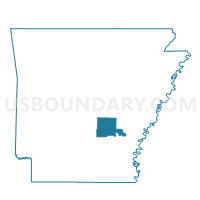
Outline

Summary
| Unique Area Identifier | 526883 |
| Name | 36 Voting District |
| County | Jefferson County |
| State | Arkansas |
| Area (square miles) | 11.23 |
| Land Area (square miles) | 11.23 |
| Water Area (square miles) | 0.00 |
| % of Land Area | 99.96 |
| % of Water Area | 0.04 |
| Latitude of the Internal Point | 34.07775190 |
| Longtitude of the Internal Point | -92.09879040 |
Maps


Graphs
Select a template below for downloading or customizing gragh for 36 Voting District, Jefferson County, Arkansas


Neighbors
Neighoring Voting District (by Name) Neighboring Voting District on the Map
- 02 Voting District, Jefferson County, AR
- 35 (Telladega) Voting District, Jefferson County, AR
- 42 Voting District, Jefferson County, AR
- 61 (Whiteville) Voting District, Jefferson County, AR
- Bowman Voting District, Cleveland County, AR
- Niven Voting District, Cleveland County, AR
- P22 Voting District, Jefferson County, AR
- P39 Voting District, Jefferson County, AR
- P40 Voting District, Jefferson County, AR
- P41 Voting District, Jefferson County, AR
- Whiteville Voting District, Cleveland County, AR
Top 10 Neighboring County Subdivision (by Population) Neighboring County Subdivision on the Map
- Spring township, Jefferson County, AR (2,751)
- Whiteville township, Jefferson County, AR (2,050)
- Niven township, Jefferson County, AR (1,682)
- Talladega township, Jefferson County, AR (1,267)
- Whiteville township, Cleveland County, AR (957)
- Bowman township, Cleveland County, AR (530)
- Niven township, Cleveland County, AR (395)
Top 10 Neighboring Unified School District (by Population) Neighboring Unified School District on the Map
- Pine Bluff School District, AR (32,104)
- Watson Chapel School District, AR (17,064)
- Cleveland County School District, AR (5,521)
- Woodlawn School District, AR (2,849)
Top 10 Neighboring State Legislative District Lower Chamber (by Population) Neighboring State Legislative District Lower Chamber on the Map
Top 10 Neighboring State Legislative District Upper Chamber (by Population) Neighboring State Legislative District Upper Chamber on the Map
Top 10 Neighboring 111th Congressional District (by Population) Neighboring 111th Congressional District on the Map
Top 10 Neighboring Census Tract (by Population) Neighboring Census Tract on the Map
- Census Tract 20, Jefferson County, AR (5,612)
- Census Tract 9701, Cleveland County, AR (4,895)
- Census Tract 21.04, Jefferson County, AR (4,054)